Geodiversity-Geoconservation
General
Geodiversity – the natural range of geological, geomorphological and soil features – is one of the main research topics of RFASE. Most of our work revolves around geomorphological mapping, and a related method for assessing the value – the geoconservation potential – of the mapped landscape elements (morphogenetic domains) has been developed. Methodololgy and results of this work are presented in Chapter 3 Geoconservation in Vorarlberg and Liechtenstein of the book Geodiversity of Vorarlberg and Liechtenstein by Seijmonsbergen et al. (2014). Whereas the landform-based approach focuses on the details of the landscape, the geodiversity (index) map of Vorarlberg by Seijmonsbergen et al. (2018) (Geodiversity index mapping) shows in a complementary manner clusters of high geodiversity based on six abiotic indices.
Linked to geodiversity is the concept of geomorphological sites (or geomorphosites). According to the International Association of Geomorphologists Working Group on Geomorphological Sites (IAG 2005), geomorphosites are portions of the geosphere that present a particular importance in the comprehension of the Earth’s history; as such they deserve special attention in landscape management. The German term “Geotop” is often used in central Europe, e.g. by Stürm (2005), who refers to “distinct components of the landscape with an outstanding geological, geomorphological or geoecological value. They are relics of, or give good insight into the Earth’s history, the evolution of life, climate or landscape.”
Landforms – more precisely: morphogenetic domains – are central to our assessment of geoconservation potential. In our work, the term geomorphosite is not restricted to unique or ‘spectacular’ geomorphological objects or groups of objects, but also includes the ‘common’ sites in which people, animals and plants live. The total abiotic landscape – all individual landscape elements and their interrelationships – is valued on the basis of detailed geomorphological information.
Geomorphosites or groups of geomorphosites in a landscape are identified as being worth conservation (protection) on the basis of a set of weighting and ranking criteria, applied within and depending on a frame of reference of choice, which is in our work the state of Vorarlberg. Strength of this approach is that a geomorphosite which is important on a local or regional scale, but not on a global scale, can be ‘captured’ and proposed for conservation, i.e. become a potential geoconservation site, with relevance on the local or regional scale. Once a potential geoconservation site has been officially elevated by the authorities within the existing legislative framework to the status of being protected, we call it a geoconservation site.
We use four traits or factors in the quantitative part of the weighting and ranking protocol: scientific relevance, frequency of occurrence, disturbance and environmental vulnerability. Scientific relevance and frequency of occurrence are the primary traits. Being geo-ecological factors, they bear most weight in our approach.
Geomorphological Mapping
Geomorphological maps at the fine scale of 1:10.000 have been made in the field by and in cooperation with staff and students of the University of Amsterdam during many decades (de Graaff et al., 1987). These maps have been converted to digital maps in a geographical information system (GIS). Nowadays, maps are made with new techniques and modern datasets in GIS. See the sub-tab Geomorphological mapping for an overview the development of geomorphological mapping in Vorarlberg. The digital maps are input to the assessment of geoconservation potential. The computer-based protocol is illustrated below with the example of the Weienreid area in northern Vorarlberg.
Geoconservation Potential
The classes of the Tier-3 morphogenetic classification scheme have been assessed by means of the traits scientific value, frequency of occurrence, vulnerability and disturbance, and have been ranked in three classes of value (high, medium, low; see table below). The classes with high value are potential geoconservation sites. The digital geomorphological map of the Weienried area in northern Vorarlberg and the corresponding map with the geoconservation potential (below) illustrate the application.

The standard weighting and ranking criteria of the assessment of geoconservation potential are shown in the above table for the Tier-3 geomorphological legend units, with numerical values and ranking. See the table to the right for the ranking matrix.

The above map shows the computer-assisted, digital, geomorphological map of the Weienried area in northern Vorarlberg (Geomorphological mapping – Computer-assisted geomorphological mapping). The map is displayed on a background of 10 m contour lines.
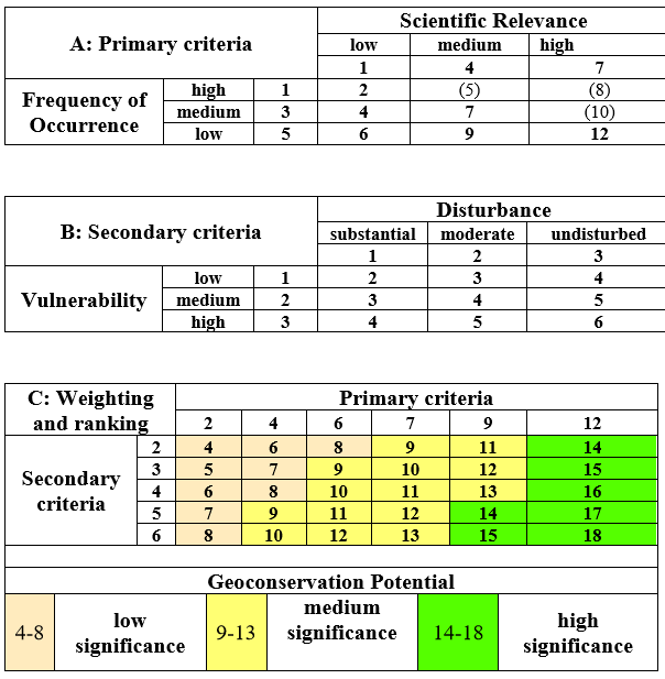
The table above shows the quantitative assessment of the weighting and ranking criteria and the matrix for the ranking of the geoconservation potential. High significance defines a potential geoconservation site.
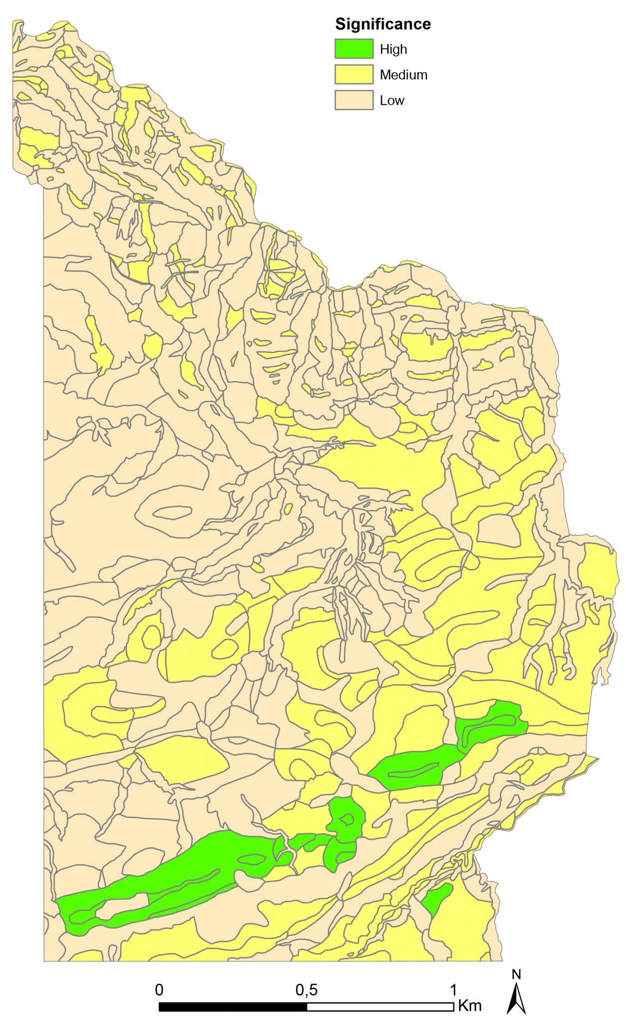
The above map shows the final geoconservation potential of the units of the digital geomorphological map (displayed on the left) of the Weienried area. The units with high significance are potential geoconservation sites. Note that small low-lying terraces (code 2212) along the Riedbach in the southern part of the map area have been down-ranked from high to medium in a final step of the assessment.
The Weienried area in northern Vorarlberg
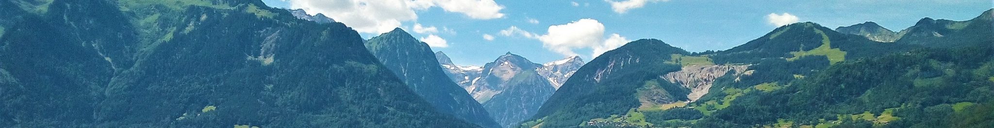
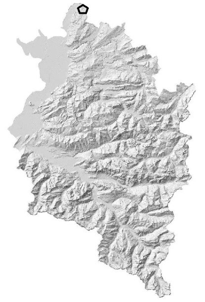
The area is situated around the Weienried hamlet in the municipalities of Möggers and Hohenweiler in the northernmost part of Vorarlberg at the boundary with Germany (altitude from approximately 850 m in the southeast to 480 m in the northwest). Morphologically, the area consists of two parts: a gently undulating terrain with overall slope to the northwest (see photo below) and, to the north of it, the southern flank of the deep incision of the Rickenbach. The undulating terrain is primarily a glacial-erosive landscape (morphogenetic type 1111; see above digital geomorphological map). A few morainic hills and ridges (codes 1312) occur between the hamlets of Weienried and Stadels. They are interpreted to have formed at the same time as the well-developed ice-marginal terraces at the village of Scheidegg to the north of Weienreid, across the federal boundary in Germany. They belong to the Second Recessional Complex as defined by De Jong (1983; see also De Jong et al., 1995), which formed at the end of the last, Würmian, ice age when the large Rhine Glacier was receding into the Alps from its maximum extent in the Alpine foreland of southern Germany. A mantle of subglacial till (code 1311) of varying thickness covers the bedrock in most of the area, with exposures in the smaller and larger incisions; it is absent in the western part.
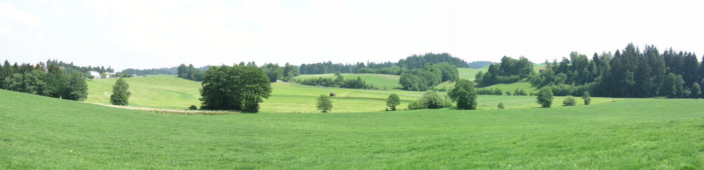
View of the gently undulating terrain to the west of the Weienried hamlet.

View to SW of the Kurlismühle hamlet in the valley of the Riedbach. Small fluvial terraces form the bottom of the valley. They are situated few metres only above the recent streambed. The trees and bushes in the centre and left part belong to Biotope 22901 (‘Aggregiertes Lebensraumtyp – 03 Ufergehölzsäume’) of the Vorarlberg Biotope Inventory.
Land use is primarily agriculture: hay meadows dominate the landscape. Originally widespread poor drainage, caused by the impermeable clay-rich subglacial till, has been remediated for agricultural purposes by installing systems of drainage pipes; shallow marshes have been drained to become meadowlands. The small incisions and gullies are overgrown by trees and bushes. The valley of the Riedbach runs through the southeastern corner of the mapped area. The Riedbach is now an underfit stream: the river is small compared to the size of the valley (codes 2211 and 2212). Regional reconstructions show that large amounts of meltwater flowed through the valley into the direction of Scheidegg and contributed to the formation of the forementioned ice-marginal terraces of the Second Recessional Complex. The flank of the valley of the Rickenbach is characterized by large mass movements: deep-seated slides (code 3111) exist which are covered with and disintegrate into smaller flow and slide landforms (code 3112). Large parts of the area are next to inaccessible due to the rugged topography, notably in the eastern part, which is locally known as Rohrach. The area is covered by forest. As of 1992 the Rohrach is a natural forest reserve, the ‘Naturwaldreservat Rohrach’.
Examples
Other examples of assessment of geoconservation potential:
- Rhine Valley – Götzis, Klaus, Fraxern and Weiler
- Gamperdona Valley – Nenzinger Himmel and the Salaruertal
- Mouth of the Gamperdonatal
- Lech
- Malbun
Literature
If you need assistance in getting access to these publications, please contact us at info@rfase.org
Graaff, L.W.S. de, Jong, M.G.G. De, Rupke, J. & Verhofstad, J., 1987, A geomorphological mapping system at scale 1: 10,000 for mountainous areas. Zeitschrift fuer Geomorphologie N.F. 31, 229-242.
IAG Working Group on Geomorphological Sites, 2005, Geomorphological sites, research, assessment and mapping. Electronic document, available at: http://geoinfo.amu.edu.pl/iag/arch/04_Annual_report_2001-5.pdf
Jong, M.G.G. De, 1983, Quaternary deposits and landforms of Western Allgaeu (Germany) and the deglaciation after the last major Pleistocene ice advance. GUA Papers of Geology 1-18, 186pp.
Jong, M.G.G. De, Graaff, L.W.S. de & Rupke, J., 1995, Der Eisabbau im Vorderen Bregenzerwald und in den Nachbargebieten (Vorarlberg, Oesterreich; Bayern, Deutschland) nach dem letzteiszeitlichen Eishochstand. Jahrbuch der geologischen Bundesanstalt 138/1, 27-54.
Seijmonsbergen, A.C., Jong, M.G.G. De, Graaff, L.W.S. de & Anders, N.S., 2014, Geodiversität von Vorarlberg und Liechtenstein. Geodiversity of Vorarlberg and Liechtenstein. Zürich, Bristol-Stiftung; Bern, Haupt. 304 S. 5 maps. ISBN 978-3-258-07888-5.
Stürm, B., 2005, Geoconservation in Switzerland. General situation 2005. GEOforumCH of the Swiss Academy of Sciences, Working Group Geotope. Electronic document available at: http://www.geosciences.scnat.ch/downloads/geotopes/GEOCONS_05_CH.pdf