The Walgau Glaciation Model
General
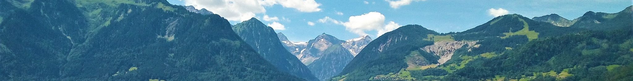
The mountains of Vorarlberg are situated on the northern side of the Alps and are open to the incoming wet air masses from the Atlantic ocean. High yearly precipitation rates are the result, notably in the Lechquellengebirge. The snowline position or equilibrium line altitude (ELA; see textbox below) of small glaciers in the region is low compared with other areas of the Alps. The lowest recorded ELA in the Säntis mountains just west of the Alpine Rhine Valley and Vorarlberg is slightly above 2400 m. The ELA in Vorarlberg gradually rises toward the south and southeast, with values between 2500 and 2600 m in the mountains of the Rhätikon and Montafon.
There is much evidence that precipitation rates were also high during the early and late phases of glaciations, at least during the Upper Pleistocene. Glaciers will have expanded rapidly from the highest regions of Vorarlberg (Silvretta and Lechquellengebirge) when climate deteriorated. The Rhine Glacier is thought to have expanded and reached Lake Constance at a depression of the ELA in the order of 600 m.
Models of mountain glaciation in textbooks tend to be rather simple and do not take into account the complex interactions of glacial and fluvial processes in the framework of climate change. The following factors are important for understanding mountain glaciations and related sedimentation processes:
- Alternating relatively warm and cold periods occurred in the Northern Hemisphere between the Eemian interglacial period (between about 130.000 and 115.000 years ago) and the Holocene, the interglacial period which started about 11.700 years ago. This is documented among other in isotope profiles of Greenland ice cores. It can be inferred from these profiles that pleniglacial periods with a fully expanded and connected glacier network in the Alps alternated with periods with a lesser ice coverage.
- Differences in altitude of the mountain ranges account for differences in net snow accumulation and, hence, for differences in valley-glacier development. When climate deteriorates, glacier growth will start in the higher mountain ranges earlier than in the lower mountains. By consequence, the major valleys will be glaciated earlier than tributary valleys with divides at lower altitudes. Conversely, the glaciers of the tributary will disappear earlier than the trunk glaciers of the major valleys when climate ameliorates.
- During periods of climate deterioration and amelioration, the interactions between streams and glaciers in mountains are complex, notably where the rivers of the ice-free lower sections of tributary valleys meet with the trunk glaciers which occupy the middle and lower reaches of the major valleys. The landforms and deposits resulting from such interactions are numerous in Vorarlberg.
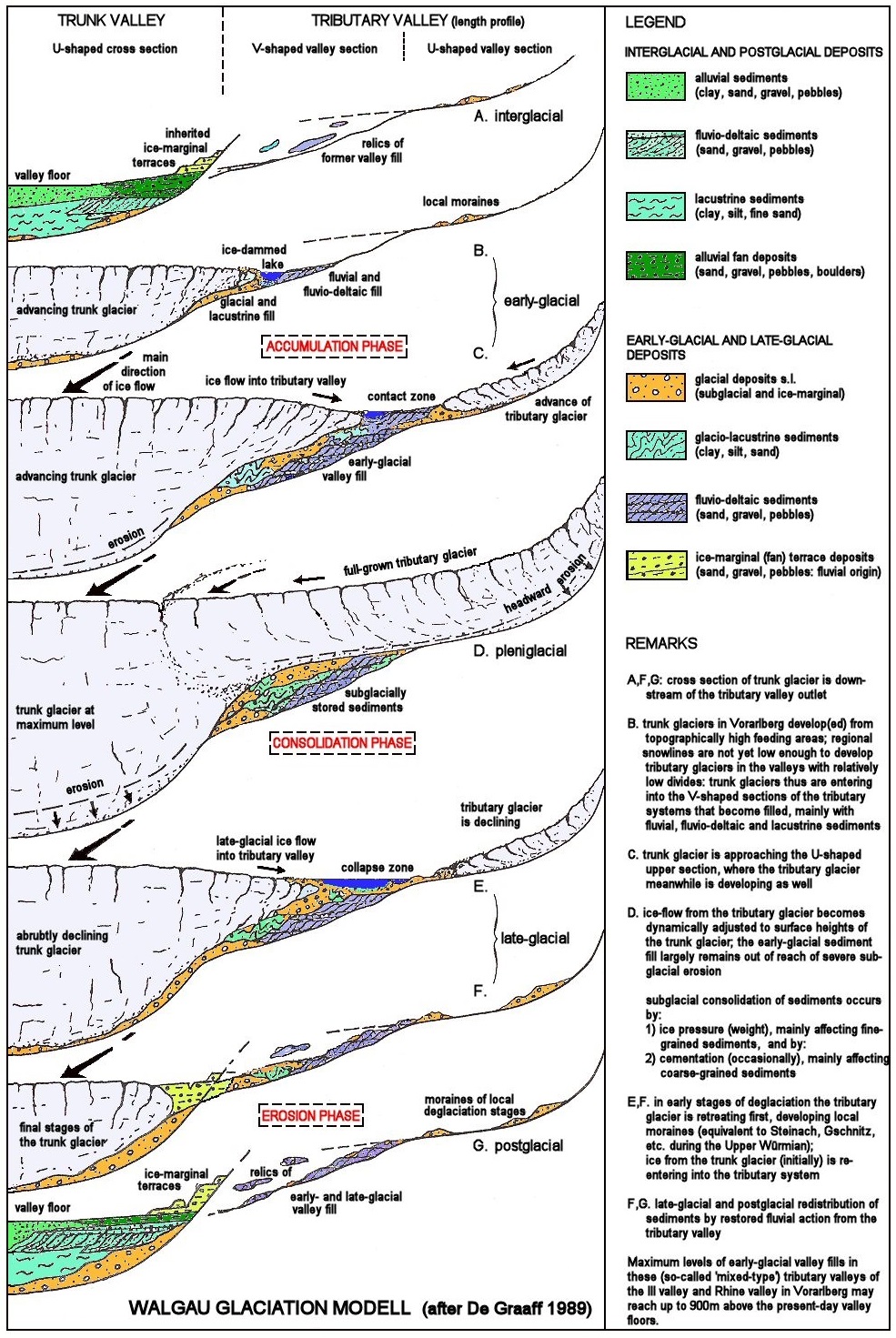
The cartoon on the left displays the sequential steps Walgau Glaciation Model.
The Walgau Glaciation Model
Three types of valley can be distinguished in Vorarlberg: 1) the U-shaped valley, created by the erosive action of a glacier, 2) the V-shaped valley, resulting from river action and mass wasting, and 3) the mixed-type of valley. Most of the tributary valleys of the Rhine and Ill valleys belong to this type. It is characterized by a complex interaction of fluvial and glacial processes. This is described by The Walgau Glaciation Model, the name referring to the Walgau region of Vorarlberg where fine field-examples of the model are found:
- Mixed-type valleys are formerly glaciated valleys with catchments ranging in size from 10 to 100 km2. Their upstream sections are “hanging” glacial troughs with low length gradients, whereas their downstream parts have a fluvial, V-shaped morphology with steep gradients. The mixed-type morphology is a persistent feature, at least predating the last glacial and interglacial periods, as shown by age datings of preserved sediments.
- When climate deteriorated, the expanding trunk glaciers in the Rhine and Ill valleys blocked the runoff from tributary valleys, which were still free of ice in their lower reaches, and penetrated into these valleys. This commonly gave rise to the formation of ice-dammed lakes in the tributary valleys. Gradually or spasmodically, these lakes shifted further up the valley with lake levels becoming higher, in response to the rising of the surface of the trunk glacier.
- The V-shaped lower sections of ice-dammed valleys served as sediment traps during glacial expansion. This happened during the accumulation phase. These early-glacial fills largely are of fluvial and lacustrine origin. Ice-contact features in these sediments are common, but glacial or glacio-fluvial deposits of the penetrating trunk glacier are less common.
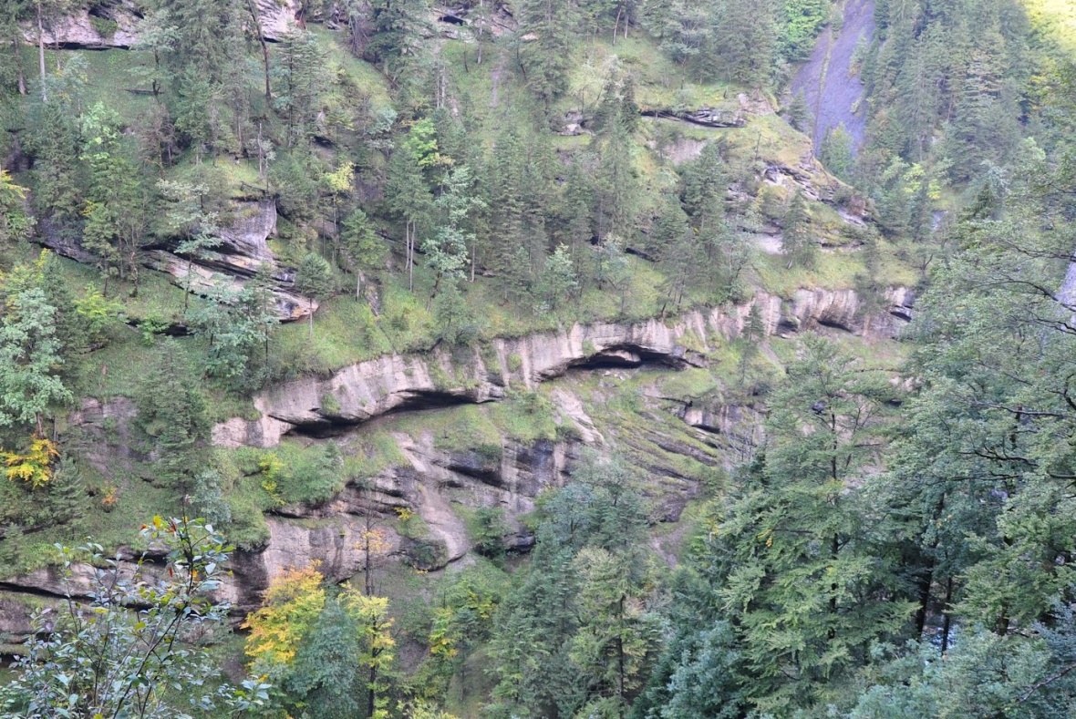
The photo on the right shows the stacking of packages of deltaic conglomerates in the lower reaches of the Gamperdonatal. Each package consists of a lower unit of inclined foreset beds and an upper unit of horizontally layered topset beds. The deposits are proof of the existence of a glacial lake which was being filled with sediments while the water level rose step-by-step. The lake resulted from the blockage of the fluvial drainage of the Gamperdonatal by the advancing Ill Gacier. Photo: Erwin Häusle, Panoramio photo id 79488136.
- Limited erosion of the valley fills occurred during full glaciation, when the sediment bodies were overridden by the trunk glaciers and the fully-developed tributary glaciers. The bed of the tributary glacier was above the early-glacial fill and was dynamically adapted to the level of the trunk glacier. This stage is referred to as the consolidation phase.
- Fine-grained sediment of the early-glacial fills are usually very dense, due to (over-)compaction by the weight of the overriding glacier. Coarse-grained sediments are commonly lithified to conglomerates and slope breccias, notably in areas with sulphate-bearing rocks (gypsum/anhydrite) in the substratum and, hence, groundwater.
- Processes reversed during deglaciation: the tributary glaciers were the first to break down when climate improved. The lower reaches of the tributary valleys became free of ice. The trunk glaciers, often, moved into the tributary valley again, but less far than in early glacial times. The valley fills became more and more exposed during the later stages, and were eroded by the tributary rivers and down-wasted by mass movement when the local base levels dropped in response to lowering surface of the trunk glaciers. This is the beginning of the erosion phase, which continues during interglacials, until a new glaciation sets in.
Literature
Cammeraat, E.C., Graaff, L.W.S. de, Kwadijk, J.K. and Rupke, J., 1987, On the origin of debris pillars in the Alps of Vorarlberg. Zeitschrift für Geomorphologie N.F. 31, 1., 85-100.
Fuchs, M., 1996, Fossile Blockgletscher in Vorarlberg, Österreich. Eine Studie über die Dynamik von Blockgletschern sowie ihre paläoklimatische und paläomorphodynamische Bedeuting im Spätglazial. Unveröffentliche Diplomarbeit Geographisches Institut Universität Heidelberg. 95 pp.
Graaff, L.W.S. de, 1996, Der fluviale Faktor bei der Entwicklung alpiner Täler und der Eisrand-Topographie in Vorarlberg (W-Österreich) während des Oberen Pleistozäns und des Holozäns. Jb. Vorarlb. Landesmuseumsverein, Freunde der Landeskunde 1997, 21-53.
Graaff, L.W.S. de, Kuijper, W.J. and Slotboom, R.T., 1989, Die Schlussvereisung und die spätglaziale Entwicklung des Moorgebietes Gasserplatz, Feldkirch‑Göfis, Vorarlberg. Jb. Geologischen Bundesanstalt, 132/2, 397-413.
Graaff, L.W.S. de, Jong, M.G.G. De and Seijmonsbergen, A.C., 2007, Landschaftsentwicklung und Quartär. In: Friebe, J.G. (Ed.), Vorarlberg. Geologie der Österreichischen Bundesländer. Geologischen Bundesanstalt, Wien, Austria, 21-32.
Keller, O., 1988, Ältere Spätwürmzeitliche Gletschervorstösse und Zerfall des Eisstromnetzes in den Nördlichen Rhein-Alpen (Weissbad-Stadium/Bühl-Stadium). Schriftenreihe Physische Geografie, Vol. 27, 2 Bände, Abbildungen & Karten. Geografisches Institut der Universität Zürich. Band A 241 pp., Band B 291 pp.
Ostermann, M., Sanders, D. and Kramers, J., 2006, 230Th/234U ages of calcite cements of the proglacial valley fills of Gamperdona and Bürs (Riss ice age, Vorarlberg, Austria): geological implications. Austrian Journal of Earth Sciences, 99, 31-41.
Seierstad, I.K., Abbott, P.M., Bigler, M., Blunier, T., Bourne, A.J., Brook, E., Buchardt, S.L., Buizert, C., Clausen, H.B., Cook, E., Dahl-Jensen, D., Davies, S.M., Guillevic, M., Johnsen, S.J., Pedersen, D.S., Popp, T.J., Rasmussen, S.O., Severinghaus, J.P., Svensson, A. and Vinther, B.M., 2014, Consistently dated records from the Greenland GRIP, GISP2 and NGRIP ice cores for the past 104 ka reveal regional millennial-scale δ18O gradients with possible Heinrich event imprint. Quaternary Science Reviews 106, 29-46.